명왕성의 산에서 평지까지

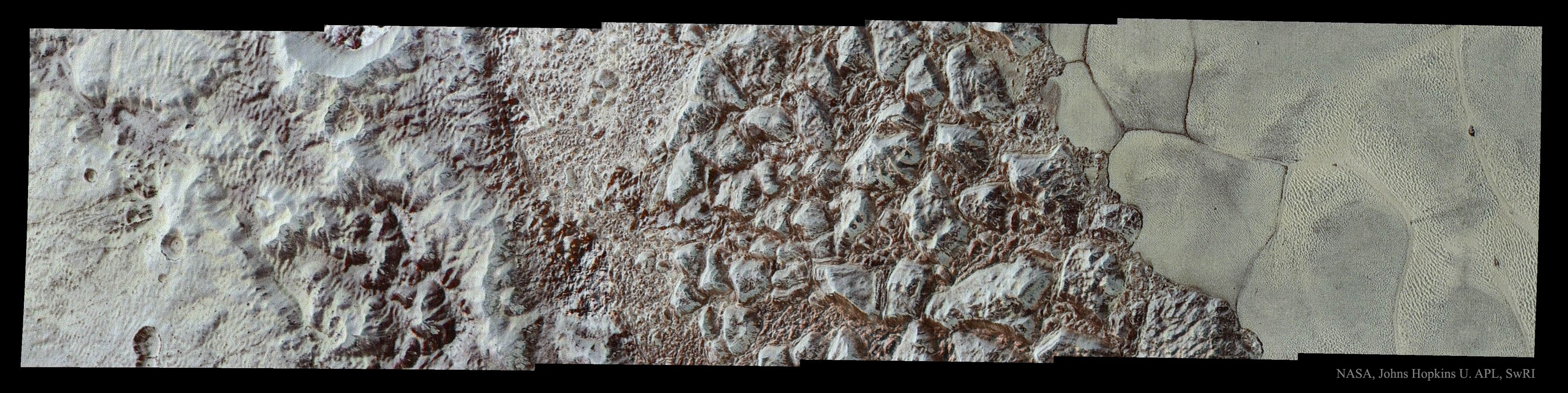
전에 없이 이렇게 선명한 명왕성의 사진은 무엇을 보여주고 있나요? 뉴 허라이즌 우주선이 태양계 바깥을 향해 이동해 가다가 7월에 역사적인 조우에서 얻은 명왕성의 고해상도 사진의 일부를 지금 보내오고 있습니다. 이 사진은 최근에 수신한 고해상도의 사진입니다. 왼쪽에 알-이드리시 산맥의 고원지대는 주로 고체 질소 덩어리들로 이루어져 있을 것으로 생각됩니다. 첨예하게 변화하는 해안선 오른쪽으로 얼음 평원이 펼쳐져 있습니다. 이 얼음 평원은 하트 모양의 특징으로 잘 알려진 스푸트니크 평원의 일부로 고체질소를 비롯한 얼음이 포함된 곳입니다. 왜 평원이 얼음 구덩이로 이루어지고 균열되어 있는지, 그 이유를 현재는 모릅니다. 이 사진은 우주선이 명왕성에 가장 가까이 접근하기 15분전에 찍은 사진이며, 폭이 약 30킬로미터에 해당하는 면적입니다. 뉴 허라이즌스 우주선의 다음 일정은 2019년 새해 첫날 카이퍼벨트 천체 2014 MU 69를 지나갈 계획입니다.
원문출처: http://apod.nasa.gov/apod/ap151214.html
Astronomy Picture of the Day
Discover the cosmos! Each day a different image or photograph of our fascinating universe is featured, along with a brief explanation written by a professional astronomer.
Pluto: From Mountains to Plains
Image Credit: NASA, Johns Hopkins U. APL, SwRI
Explanation: What do the sharpest views ever of Pluto show? As the robotic New Horizons spacecraft moves into the outer Solar System, it is now sending back some of the highest resolution images from its historic encounter with Pluto in July. Featured here is one recently-received, high-resolution image. On the left is al-Idrisi Montes, mountainous highlands thought composed primarily of blocks of water ice. A sharp transitional shoreline leads to the ice plains, on the right, that compose part of the heart-shaped feature known as Sputnik Planum, which contains ices including solid nitrogen. Why the plains are textured with ice pits and segmented is currently unknown. The image was taken about 15 minutes before closest approach and shows an area about 30 kilometers across. The New Horizons spacecraft is next scheduled to fly past Kuiper Belt object 2014 MU 69 on New Year's Day 2019.
AAS Members: How does APOD help you?
Tomorrow's picture: buenos arcs
'국문 APOD > 2015' 카테고리의 다른 글
| [APOD] 오리온 성운의 먼지(2015.12.29.) (0) | 2015.12.29 |
|---|---|
| [APOD] 피뇬 소나무에 장식된 별들(2015.12.24.) (0) | 2015.12.24 |
| [APOD] Arp 87: 허블우주망원경으로 본 합병하는 은하들(2015.12.9.) (0) | 2015.12.09 |
| [APOD] 빈 공간으로부터의 힘: 카시미르 효과(2015.12.6.) (0) | 2015.12.06 |
| [APOD] 화성 위에 검은 모래가 흘러내리다.(2015.11.29.) (0) | 2015.11.29 |