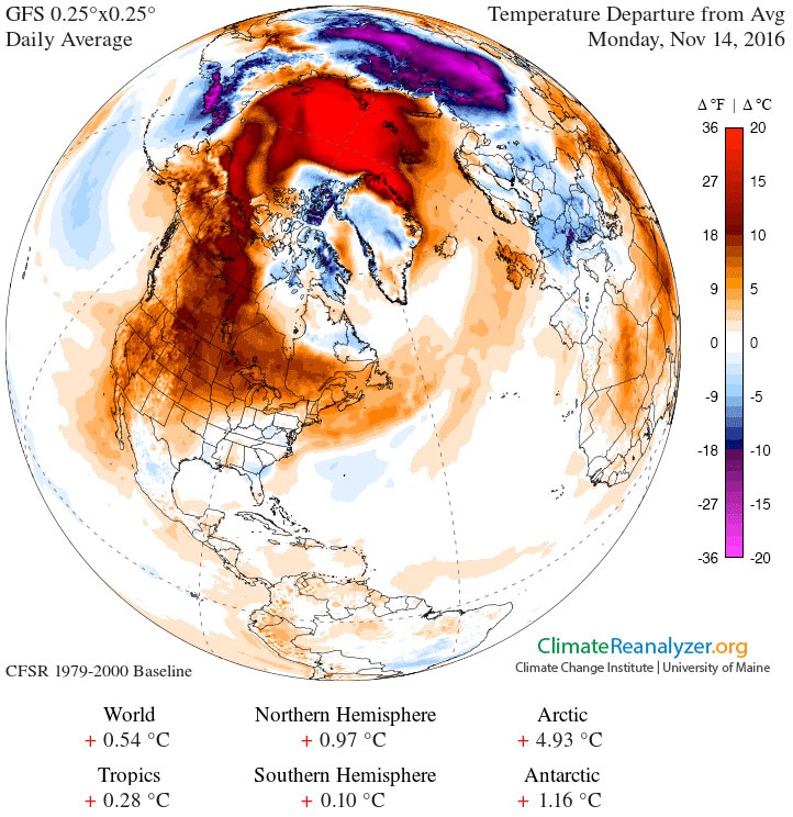
북아메리카 대륙의 늦어진 추위

북아메리카의 북쪽이 왜 이렇게 따뜻할까요? 보통의 이맘때, 11월 중순의 기온은 이보다 평균 30도(화씨?)정도 더 춥습니다. 유럽은 여기처럼 따뜻해 보이지 않습니다. 한 가지 요인은 유달리 크고 안정적인 고기압 영역이 캐나다 위에 형성되어서 일반적으로 더 차가운 극지방 공기를 막고 있기 때문인 것으로 보입니다. 비록 기후 패턴의 근본적인 원인이 일반적으로 복잡하지만, 이 지속적인 캐나다의 안티사이클론 지역은 지난 겨울에 발생했던 엘니뇨, 즉 태평양 중부의 해수면 온도가 평균보다 따뜻했던 것과 관련된 것으로 추론됩니다. 하지만 이 온화한 기후를 북아메리카 사람들은 즐겨야할 겁니다. 다음 일, 이주 안으로 지금 태평양 중부지역에 온도가 평균보다 차가운 라니냐가 북아메리카의 바람과 기온 패턴에 영향을 주기 시작할 겁니다.
원문출처: https://apod.nasa.gov/apod/ap161115.html
Astronomy Picture of the Day
Discover the cosmos! Each day a different image or photograph of our fascinating universe is featured, along with a brief explanation written by a professional astronomer.
Image Credit: Climate Reanalyzer, CCI, U. Maine
Explanation: Why is it so warm in northern North America? Usually during this time of year -- mid-November -- temperatures average as much as 30 degrees colder. Europe is not seeing a similar warming. One factor appears to be an unusually large and stable high pressure region that has formed over Canada, keeping normally colder arctic air away. Although the fundamental cause of any weather pattern is typically complex, speculation holds that this persistent Canadian anticyclonic region is related to warmer than average sea surface temperatures in the mid-Pacific -- an El Niño -- operating last winter. North Americans should enjoy it while it lasts, though. In the next week or two, cooler-than-average temperatures now being recorded in the mid-Pacific -- a La Niña -- might well begin to affect North American wind and temperature patterns.
'국문 APOD > 2016' 카테고리의 다른 글
| [APOD] 라스 캄파나스의 달과 수성(2016.8.6.) (0) | 2017.03.29 |
|---|---|
| [APOD] 명왕성의 스푸트니크 평원 (2016.11.22.) (0) | 2017.03.28 |
| [APOD] 타란툴라(독거미) 성운의 우주 거미줄 (2016.11.8.) (0) | 2017.03.28 |
| [APOD] 어두운 하늘을 가로지르는 물결(2016.7.30.) (0) | 2017.03.28 |
| [APOD] 여름 행성들과 은하수(2016.7.23.) (0) | 2017.03.28 |